Tasking Satellite Imagery
In this section, you will learn how to use to purchase future imagery by directly commissioning satellite tasking through the platform.
To order imagery using tasking, do the following:
| Step | Field | Description | What It Means |
|---|---|---|---|
| 1 | Vendor | Select satellite data provider. | Determines satellite constellation availability, collection capabilities, and product offerings; affects downstream processing options and licensing terms. |
| 2 | Start and End Date & Time | Set the start and end date of the collection window. | Defines the earliest time when the satellite should attempt to capture imagery; UTC conversion provided for cross-timezone consistency. |
| 3 | Product | Select a type of imagery product. | Specifies illumination conditions for collection; affects image characteristics and use cases. |
| 4 | Offering | Select a service tier or product bundle. | Determines priority level, collection attempts, and delivery timeframes; higher tiers typically receive expedited handling. |
| 5 | License Type | Select the terms governing imagery usage rights. | Defines legal usage constraints, sharing permissions, and redistribution rights; affects compliance requirements. |
| 6 | Withhold | Select exclusivity setting for collected imagery. | Controls whether imagery will be withheld from other customers; affects pricing and availability to other platform users. |
| 7 | Draw | Select the point tool for manually defining the Area of Interest on a map. | Enables interactive point definition for spatial targeting. The exact geographic extent to be captured; directly impacts collection feasibility and pricing. |
| 8 | AOI Library | Select a pre-saved Area of Interest from the system library. | Provides access to stored spatial definitions for consistent, repeatable tasking across projects. The exact geographic extent to be captured; directly impacts collection feasibility and pricing. |
| 8 | WKT | Select to insert Well-Known Text representation of a spatial geometry. | Enables programmatic definition of complex spatial queries using standard geometric notation. The exact geographic extent to be captured; directly impacts collection feasibility and pricing. |
| 9 | Description | Write optional text field for task identification. | Provides context and searchable metadata for the tasking request. |
| 10 | License Agreement | Select the License Agreement checkbox to confirm acceptance of vendor's terms. | Legal requirement for submission; enforces acknowledgment of the vendor's license terms. |
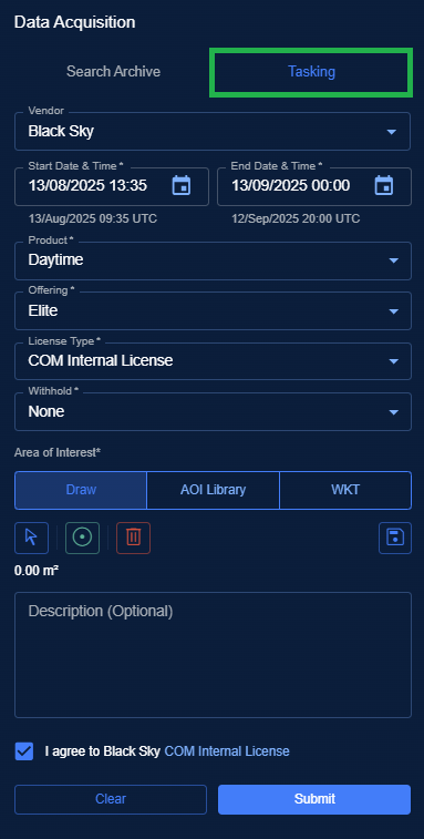
- Click the Submit button to place order for imagery purchase.
The platform displays the Tasking Summary dialog box for you to confirm the order. Once confirmed the order is placed successfully. The Tasking Summary dialog box presents the tasking order information namely Vendor Name, Start Date and Time, End Date and Time, Product, and Estimated Pricing.
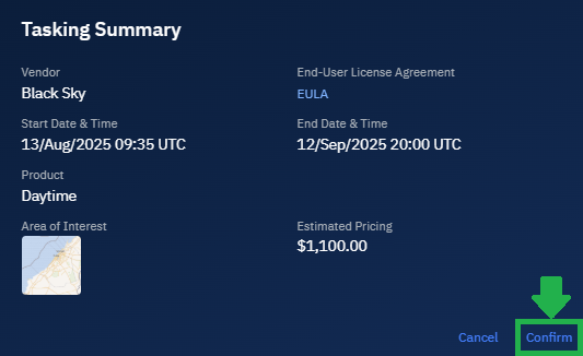
- In the Tasking Summary dialog box, click the Confirm button.

The Order Submitted confirmation box is displayed.
- In the Order Submitted confirmation box, click the My Orders button to monitor the progress of your order.